FMJ Facilities Management magazine providing industry-specific intelligence to FM and property professionals


- Innovative use of digital mapping helps hospital remain safe
- Makes process of inspecting 20,000 concrete planks 50% more efficient
Airedale General Hospital has gone live with a new geospatial system to help manage its RAAC (reinforced autoclaved aerated concrete) monitoring and repairs programme. Using GIS (Geographic Information System) software from Esri UK, the system replaces paper-based processes with digital workflows to improve the accuracy and efficiency of RAAC inspections.
The software reveals where the highest risk areas are in real-time, which informs the mitigation works, including temporary propping, steel reinforcements and fixing roof leaks, to maintain the safe operation of the hospital.
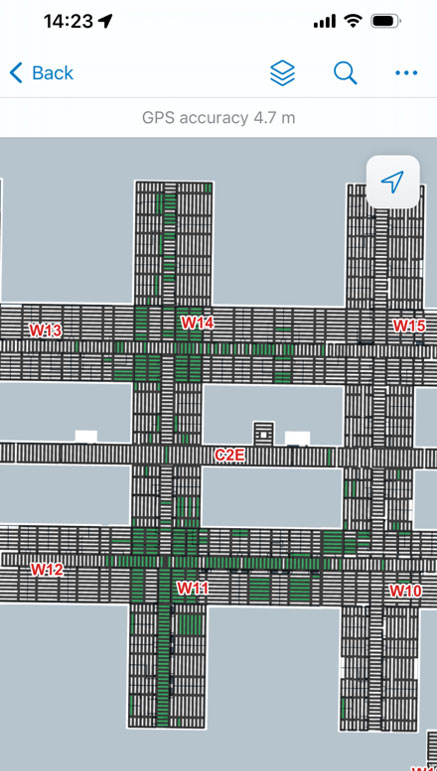
The solution has introduced 50% efficiency savings in the RAAC surveying process, which involves a team of eight inspecting 20,000 RAAC planks across 52 departments. Airedale General Hospital has one of the highest quantities of RAAC panels in the NHS, with 83% of the hospital’s floors, walls and ceilings made of the material. Built in the late 1960s, the hospital near Keighley, West Yorkshire first discovered its RAAC problem five years ago and is due to be rebuilt by 2030 as part of the government’s New Hospital Programme.
Previously, the RAAC inspection process relied on hand-written surveys to record defects, including cracks, movement or moisture, which were then transferred into Excel. Photos were uploaded manually and separate paper floor plans updated to show the changes to risk across each ward. In 2023, the hospital identified the need for a more sophisticated method to help perform complex calculations for tracking defects and monitoring how different sections of planks were deteriorating at different rates.
Richard Burgin, Estates Project Manager, Airedale General Hospital explained: “The existing manual survey process was not capable of dealing with the sheer volume of work. It became obvious the hospital needed a single, joined-up view of RAAC risk to generate the inspection frequencies and the ongoing programme of remediation works. The Esri GIS has given us a more robust and resilient process, with a reduced risk of human error that instantly shows different levels of risk so we know where to focus. RAAC has a major operational impact, sometimes disturbing clinical and operational functions so surveys and mitigation work needs to be accurate and fast and the system underpins that.”
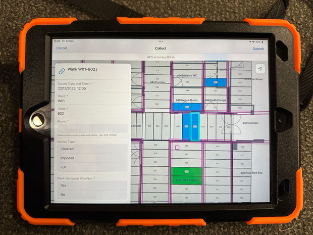
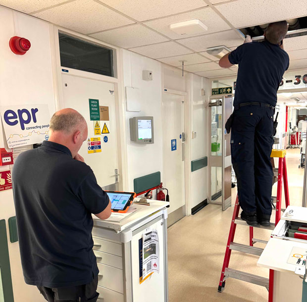
Inspection data is now collected on iPads using custom forms, which helps dictate the risk rating of each plank. Planks are surveyed either monthly, 3-monthly, 6-monthly or yearly, depending on their rating, in line with current guidance. Dramatically reducing the time needed to record, analyse and report on defect data, the surveying process has become 50% more efficient. The output helps instruct the survey team which wards they need to survey and which planks are due for inspection.
Patterns of deterioration identified
Improved insights are now generated faster than before, as the GIS can run different spatial analysis and scenarios, including tracking monthly changes in residual risk and providing detailed information relating to each specific concrete plank. Patterns of deterioration can be clearly seen and investigated on an estate map, overlaid with drone imagery, which helps all stakeholders understand the problem more easily. Factors which impact on RAAC, such as the location of utilities and services, the orientation of a building and prevailing weather can all be better assessed using this method.
The digital workflow also provides Airedale with a solid audit trail which helps with compliance and reporting, which is directly linked to the government funding it receives to manage RAAC.
Richard Burgin continued: “The GIS is a powerful tool which helps manage the sheer volume of work, provides a single source of truth on RAAC risk and helps prioritise where repairs and interventions should focus to keep the hospital running safely. The digital approach increases the accuracy of the data and makes it more shareable, improving the ability to communicate the scale and complexity of the problem, with both internal and external stakeholders.”
Mike Atherton, Managing Director of AGH Solutions Ltd, commented: “The new geospatial system plays a significant role in helping us to take every step possible to maintain a safe environment to provide high quality health services for our community. By helping to pinpoint priority locations it not only helps focus resources to deal with the immediate issue but also assists in planning the ongoing operation of the hospital and minimising disruption.”
Future plans
Future plans at Airedale General Hospital include the creation of dashboards to further enhance how RAAC data is reported and consumed, allowing hospital staff to self-serve and generate their own statistics using different parameters. KPIs will be available on the dashboards to further aid the management of the problem from an operational and financial perspective.
Paul Clarke, Head of Government, Esri UK said: “The Airedale General Hospital project is the first of its kind in the UK and showcases best practice in the advancement of RAAC management. Defining the risk from RAAC is a significant challenge across the public sector, including hospitals, schools and other public buildings. Interest in the geospatial approach has been high as mapping the indoors helps organisations to understand the risk in a cost-effective, accurate and efficient way and then prioritise mitigation works. It helps keep buildings safe, open and delivering services to the public.
“Using dashboards to visualise the data makes it easy to share new insights with key stakeholders, from board directors to contractors. People have been using maps in the outdoor world for centuries but indoor mapping is relatively new. Moving indoors with mapping opens up many new benefits to help manage assets, from RAAC to asbestos.”
Airedale General Hospital will be talking about its advancement of RAAC management in a webinar on Wednesday 22 May. Heathrow’s property team will also be discussing how using GIS is helping to manage 1.4 million square feet of commercial space.
Registration details can be found here.
-ends-
The view or information contained within these unedited press releases, are that of the company producing it and not necessary the views of kpm.