FMJ Facilities Management magazine providing industry-specific intelligence to FM and property professionals

The Met Office’s Climate Data Portal has gone live today, giving organisations improved access to climate data and other resources, allowing them to better understand and respond to climate change. Part of the Met Office’s wider strategy to maximise the benefits of its data, the portal contains 60 different data layers, as well as guidance and information.
Built using geospatial technology from Esri UK, the portal makes it easier for any business or government organisation to combine open climate data with their own data and reveal the future impact of extreme conditions on their operations, including heatwaves, floods or droughts.
Combining Met Office expertise and authoritative data with Esri’s geospatial tools, the portal presents complex scientific climate projections in easy-to-use formats, ready to visualise and analyse in GIS and non-spatial applications or integrate into business processes for improved decision making. Spatial analysis can be performed at a global, regional or local level enabling location-specific action plans to be developed.
The project is part of the strategic partnership between the Met Office and Esri UK who have been working together for over 20 years.
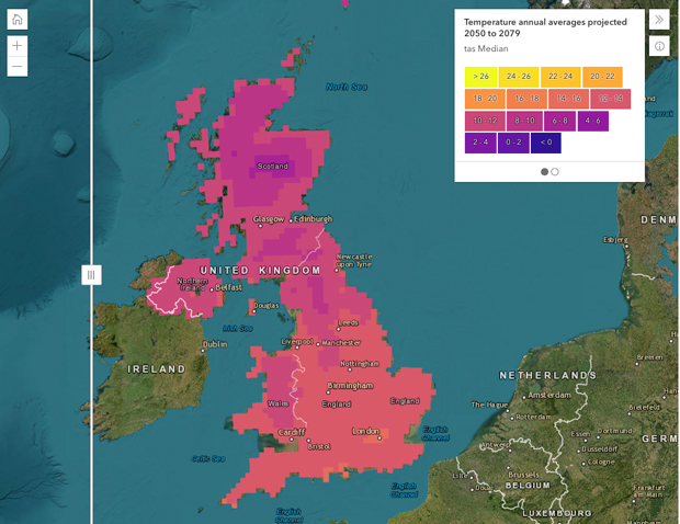
Professor Jason Lowe, Head of Climate Services at the Met Office said: “Historically, climate science has defined the problem, now it’s moving to help with the solution, providing information at a local level which is highly relevant to UK organisations. By combining the Met Office’s latest projections with Esri UK’s geospatial tools, the reach and value of this data is greatly extended. UK stakeholders can investigate their physical climate risks over the next 50 to 100 years. The most detailed climate projections reveal a greater chance of warmer, wetter winters and hotter, drier summers and these help users plan and prepare for extreme weather, climate change and the reporting which new regulations, linked to climate change, will require.”
Data on temperature extremes can be used to understand the impacts on transport infrastructure, health and energy demand. For example:
- Days above 25°C can indicate when trains could be disrupted due to overheating of railway infrastructure
-
Nights above 20°C can indicate heat stress as night time temperatures impact the body’s ability to recover from higher daytime temperatures
-
Days below 0°C can indicate transport disruption and increased energy demand for heating.
The portal will also help provide insight to help organisations start their response to regulatory climate reporting such as TCFD (Task Force on Climate-related Financial Disclosures), which is being rolled out across the UK.
Pete Wilkinson, Managing Director of Esri UK said: “The Climate Data Portal is a giant step forward in making climate data more usable for UK stakeholders. Climate change presents a major challenge and this challenge is a geographic one. Using geospatial technology as a delivery mechanism for climate data makes it quickly accessible and usable in spatial and temporal analysis, helping to identify at-risk areas and develop location-specific action plans.”