FMJ Facilities Management magazine providing industry-specific intelligence to FM and property professionals

Location intelligence is helping London Gatwick and Carter Jonas to manage large estates and assets. From property portfolios to housing associations, public buildings to airports, geospatial solutions are enabling owners and operators to make better decisions, driving efficiency, sustainability and reliability.
Understanding location has never been more critical in helping to solve some of the major challenges within facilities, land and property management.
Providing powerful maps, apps, dashboards and tools to manage spatial data, Esri’s ArcGIS can be the foundation stone of a digital twin, giving visibility of the locations and condition of assets and spaces. Mobile apps are improving the efficiency of facilities inspections or site surveys, while online maps and KPI dashboards are being used to share insights into the health and maintenance of the built environment.
Outdoor spaces have long been digitally mapped, allowing better decisions to be made about how they are managed. But now mapping is moving inside, giving users an interactive, real-time operational view of any indoor space. Challenged to achieve more with less, indoor mapping is now helping estates and facility managers tackle rising costs, optimise space usage and streamline maintenance tasks.
London Gatwick tackles buried assets and biodiversity
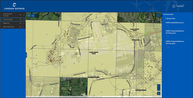
London Gatwick has created a new geospatial platform using Esri’s ArcGIS system to support multiple operational areas at the airport, including engineering and environmental services. The system is already making engineering and construction works safer by reducing accidental strikes on buried assets and enabling better management of the airports biodiversity.
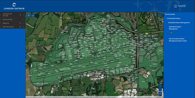
The geospatial platform contains critical infrastructure information spanning the 70-year history of the airport, including BIM, CAD, utilities, environmental, carbon, aerial photography and legacy data. By integrating all spatial data into a single view, the Esri platform provides new insights to support better collaboration and decision-making across the site.
Field engineers, third party contractors and major consulting firms all use the same single view of asset data, accessible on any device, when planning works. With up to 50 engineering and construction projects on site at any one time, the new system is making work safer and reducing risk of disruption to airport operations from any unplanned outages.
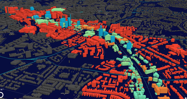
Insights from the GIS allow London Gatwick to plan works around any environmentally sensitive sites to minimise impact and seek ways to bring additional benefits, such as improving biodiversity. The embodied carbon data allows users to see the carbon ‘price’ of assets, supporting sustainability decisions by showing the potential carbon emissions of demolitions or new construction.
Being able to visualise and interrogate all spatial data from any discipline, on any device, is critical to the sustainable future of London Gatwick. Democratising spatial data in this way drives significantly more business and operational value from it.
As a complex site with over 70 years of history, the airport is building a virtual representation of what has previously been built along with future plans, which helps manage its development.
Carter Jonas transforms property inspections
Multi-disciplinary property consultancy Carter Jonas has completely transformed its property inspection process using Esri’s ArcGIS system. The new end-to-end solution removes 25,000 hours of manual administrative work every year and enables the business to provide a more efficient and sustainable service for clients.
Carter Jonas manages large portfolios of commercial, residential and rural property on behalf of its clients, many of which have hundreds of individual properties all around the country. As part of these property management contracts, the organisation carries out more than 5,000 property inspections per year, including condition and hazard inspections for tenanted homes.
Now in use across Carter Jonas’ 34 offices nationwide, the new Esri-based solution has replaced paper-based forms with a series of digital surveys. Asset managers capture inspection information on their smartphones while at client properties and attach pictures. All the inspection data is uploaded directly to a centralised database, where it is combined with data from the company’s property management system.
Asset managers then view inspection results and property management information via a mapping app. Accurate, up-to-date information about all properties in large portfolios can be viewed and analysed using map dashboards.
Benefits
- Carter Jonas now produces inspection reports in 45 minutes instead of 4-6 hours
- Asset managers can easily identify similar issues across multiple properties and help clients to reduce maintenance costs
- Carbon emissions are decreased due to shorter journeys from more efficient routing
- Data security and data currency are improved
In the future, Carter Jonas plans to integrate its inspections with data from indoor positioning systems, drones and remote sensors, creating digital twins that will help it manage properties throughout their lifetime.
Free webinar
To find out more about property and estates management using location intelligence, register for Esri UK’s free webinar, featuring speakers from Heathrow and Airedale General Hospital.
Heathrow’s property team will be discussing how using GIS is helping to manage 1.4 million square feet of commercial space, to increase revenue and provide a better customer experience, while Airedale General Hospital is taking a geospatial approach to improve the efficiency of building inspections and advance its management of RAAC.
Taking place on Wednesday 22 May at 11:00am-12:00pm, registration details can be found here.